
The Canary Islands form one of the most unique regions of Spain. They are a volcanic archipelago located in the Atlantic Ocean, close to the northwestern coast of Africa. The group contains eight main islands and several smaller islets, each with its own landscape, capital, character and history. This guide explains their names, capitals, provincial organisation, location and other essential facts in a clear and easy way.
Quick overview of the Canary Islands
| Number of main islands | 8 |
| Official islets | 5 |
| Number of capitals | 2 |
| Provinces | Santa Cruz de Tenerife and Las Palmas |
| Largest island | Tenerife |
| Smallest island | El Hierro |
| Newest recognised island | La Graciosa |
| Continent closest to the islands | Africa |
| Distance from Africa | Approximately 100 kilometres |
| Political status | Autonomous Community of Spain |
Names of all the Canary Islands
The archipelago is made up of the following eight main islands:
- Tenerife
- Fuerteventura
- Gran Canaria
- Lanzarote
- La Palma
- La Gomera
- El Hierro
- La Graciosa (officially recognised as an island)
Smaller and uninhabited islets that also belong to the Canary archipelago include:
- Isla de Lobos
- Montaña Clara
- Alegranza
- Roque del Este
- Roque del Oeste
Although small, these islets are part of the natural and geographic identity of the region and belong to the Autonomous Community of the Canary Islands.

Table of islands and their capitals

| Island | Capital | Province | Notes |
|---|---|---|---|
| Tenerife | Santa Cruz de Tenerife | Santa Cruz de Tenerife | The most populated island and home to Mount Teide |
| La Palma | Santa Cruz de La Palma | Santa Cruz de Tenerife | Known for its forests, volcanic scenery and astronomy |
| La Gomera | San Sebastián de La Gomera | Santa Cruz de Tenerife | Famous for Garajonay National Park and the whistling language Silbo Gomero |
| El Hierro | Valverde | Santa Cruz de Tenerife | The smallest and westernmost island |
| Gran Canaria | Las Palmas de Gran Canaria | Las Palmas | One of the two capitals of the archipelago |
| Fuerteventura | Puerto del Rosario | Las Palmas | Longest beaches and strong winds that attract water sports |
| Lanzarote | Arrecife | Las Palmas | Known for Timanfaya National Park and volcanic landscapes |
| La Graciosa | Caleta del Sebo | Las Palmas | The newest officially recognised island |
The two provinces of the Canary Islands
The Canary Islands are organised into two provinces. This division simplifies administration and reflects historical development.
Province of Santa Cruz de Tenerife
- Tenerife
- La Palma
- La Gomera
- El Hierro
Province of Las Palmas
- Gran Canaria
- Fuerteventura
- Lanzarote
- La Graciosa
Each island except La Graciosa has its own Island Council, known as a Cabildo, which has major responsibility for local services, development and cultural matters.
Why the Canary Islands have two capitals

One of the most distinctive features of the archipelago is its dual capital system. The Autonomous Community has two capitals:
- Santa Cruz de Tenerife
- Las Palmas de Gran Canaria
The distribution of institutions reflects a political balance between the two provinces. Some governmental bodies are located in Santa Cruz de Tenerife while others are based in Las Palmas de Gran Canaria.
For example, the Parliament of the Canary Islands is located in Santa Cruz de Tenerife, while the Government Delegation operates from Las Palmas de Gran Canaria. The presidency alternates between the provinces in different legislative periods. This shared arrangement ensures equal representation for both halves of the archipelago.
Capitals of each Canary Island
- Tenerife: Santa Cruz de Tenerife
- Gran Canaria: Las Palmas de Gran Canaria
- Fuerteventura: Puerto del Rosario
- Lanzarote: Arrecife
- La Palma: Santa Cruz de La Palma
- La Gomera: San Sebastián de La Gomera
- El Hierro: Valverde
- La Graciosa: Caleta del Sebo
Where the Canary Islands are located
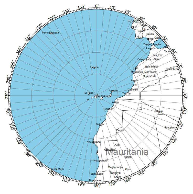
The Canary Islands are found in the Atlantic Ocean, off the northwest coast of Africa. They lie close to Morocco and Western Sahara and much further from mainland Spain. The archipelago sits roughly between latitudes 27 and 29 degrees north.
Distances in simple form:
- About 100 kilometres from the African coast
- More than 1000 kilometres from the Iberian Peninsula
- Direct flights from Spain take around two and a half hours
Despite their location off Africa, the islands belong entirely to Spain and form part of the European Union.
Why the islands are called the Canary Islands
The name does not come from the canary bird. The origin is older and relates to the Latin term “Canariae Insulae”, which means Islands of the Dogs. Ancient Roman sources described large dogs living on the islands, which may have inspired the name. Another theory connects the name to monk seals, which were once common and were sometimes called sea dogs.
The canary bird was named after the islands, not the other way around.
The Canary Islands and their waters

The land area of the islands is about 7500 square kilometres, but when the adjacent maritime zone is included, the total territory referred to as Canary waters expands to more than 29000 square kilometres. This concept highlights the importance of the surrounding sea for fishing, transport and ecological protection.
Important cities of the archipelago
- Las Palmas de Gran Canaria
One of the two capitals. Known for culture, beaches and history. - Santa Cruz de Tenerife
The other capital. Known for its port, museums and the famous carnival. - Arrecife
Capital of Lanzarote and an important administrative centre. - Puerto del Rosario
Capital of Fuerteventura with growing cultural life. - San Cristóbal de La Laguna
UNESCO heritage city on Tenerife with colonial architecture. - Telde
A historic city in Gran Canaria.
Frequently asked questions

How many Canary Islands are there
There are eight official islands. La Graciosa is the newest officially recognised island. There are also five islets.
What are the names of all the Canary Islands
Tenerife, Gran Canaria, Fuerteventura, Lanzarote, La Palma, La Gomera, El Hierro and La Graciosa.
What is the capital of the Canary Islands
The archipelago has two capitals: Santa Cruz de Tenerife and Las Palmas de Gran Canaria.
Why are there two capitals
The dual capital system gives equal representation to the two provinces. Some government bodies are in Santa Cruz de Tenerife and others are in Las Palmas de Gran Canaria.
Are the Canary Islands part of Spain
Yes. They are an Autonomous Community of Spain and part of the European Union.
Where are the Canary Islands located
In the Atlantic Ocean near the northwestern coast of Africa, about 100 kilometres from Morocco.
What are the provinces of the Canary Islands
Santa Cruz de Tenerife and Las Palmas.
What islands belong to the province of Santa Cruz de Tenerife
Tenerife, La Palma, La Gomera and El Hierro.
What islands belong to the province of Las Palmas
Gran Canaria, Fuerteventura, Lanzarote and La Graciosa.
Which is the largest Canary Island
Tenerife is the largest in size and population.
Which is the smallest Canary Island
El Hierro is the smallest of the main islands.
Why are they called the Canary Islands
The name comes from the Latin term for Islands of the Dogs, not from canary birds.
How many people live in the Canary Islands
More than two million inhabitants across all islands.
What is the capital of each island
Each island has its own capital. The list is provided above in full.
Conclusion
The Canary Islands form a diverse and fascinating archipelago with eight main islands, two capitals and a unique administrative structure. Their landscapes, climate and cultural heritage make them one of the most special regions in Spain. Understanding their names, capitals and provinces provides a clear picture of how this Atlantic community is organised and why it plays such an important role within the country.